Transport Yourself: Hikes for History Buffs

Many of the trail systems in New England and the mid-Atlantic are rich in history as well as beauty and versatility. From repurposed railroads to ancient foot paths used by Indigenous peoples, history-lovers and hikers alike will enjoy these 6 fascinating and beautiful walks sure to transport you to a bygone era.
MACKWORTH ISLAND STATE PARK AND BAXTER SCHOOL FOR THE DEAF | Falmouth, Maine
Mackworth Island State Park is a great day trip for families, with breathtaking views of the Portland skyline and Casco Bay and its many islands. Take the 1.25-mile, handicap-accessible loop around the perimeter of the island, past the turn-of-the-century brick mansion of former Maine governor Percival P. Baxter and the present-day Baxter School for the Deaf, Maine’s first mixed-residential, multi-educational school for the hearing-impaired. Start at the parking lot and follow the trail in either direction. The packed gravel terrain is mostly level, with some steeper side paths to the beaches (handicapped travelers should take the ramp to the left of the parking lot to access the beach). The island is also home to a historic granite pier which was used for offloading and onloading freight from vessels during the Civil War and after. Today, it’s a great spot for fishing, picnicking, or just enjoying the view of the bay. There is an entrance fee of $3 for Maine residents, $4 for non-residents, and the park is open from 9 a.m. to 5 p.m. year-round.
Level: Easy
Distance: 1.25-mile loop
Information: Maine Department of Agriculture, Conservation, and Forestry

ROBERT FROST INTERPRETIVE TRAIL | Ripton, Vt.
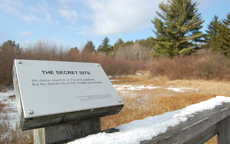
History and poetry lovers will delight in this road less traveled. Located near the former home of Robert Frost, this National Historic Site offers a quick, 1.2-mile hike to commemorate the poet’s life and work, with his poems mounted along the trail. Start your hike at the parking lot trailhead off Route 125 in Middlebury and follow the path to the left. A boardwalk leads you over the wetlands of the Middlebury River—at the junction 0.1-mile in, stay to the left. You will reach a second junction at the 0.2-mile marker, and again will stay to the left—this will take you on a 0.8-mile loop back to that second junction. Follow the trail back to the first junction and turn left to loop back to your car.
Level: Easy
Distance: 1.2-mile loop
Information: U.S. Forest Service
THE FREEDOM TRAIL | Boston, Mass.
Boston’s Freedom Trail is perhaps one of the best-known historical walks in the United States and tells the story of the city’s involvement in the Revolutionary War. Walking the trail is a great way for visitors and locals alike to get to know Boston and explore it on foot. The 2.5-mile trail starts at Boston Common and passes by 16 historic sites, before ending at the Bunker Hill Monument in the Charlestown neighborhood. (Note: With concerns over COVID-19, be sure to make a plan to return to your car safely.) The trail is marked by a ribbon of red and white bricks molded or painted onto the sidewalk, with stops at the Old North Church, the site of the Boston Massacre, and the USS Constitution, the world’s oldest active naval vessel. Hiking the Freedom Trail is free, but entrance to some of the attractions such as the Old North Church and USS Constitution require a fee. While COVID-19 restrictions have limited many of the in-person guided tours of the Freedom Trail, you can still turn your smart phone into a personal tour guide with a self-guided audio tour such as this one offered by ActionTourGuide.com.
Level: Easy
Distance: 2.5 miles start to end
Information: Boston Freedom Trail
BALD MOUNTAIN AND DOODLETOWN LOOP TRAIL | Stony Point, N.Y.
This 5.7-mile loop leads hikers over a steep trail to a panoramic view atop Bald Mountain and descends through the surrounding woods and to the historic, abandoned “ghost town” of Doodletown. The hamlet thrived for 200 years and was a crossroads during the American Revolution, and later a mining town. Now abandoned, remains of mines can be viewed from the trail. Park in the lot off Route 9W near Iona Island and cross the street to follow the blue-blazed Cornell Mine Trail. Continue straight at the first intersection, about 0.6-mile into your hike. At 1.4 miles, you will reach a junction with the red-blazed Ramapo-Dunderberg Trail—turn right to climb to the summit of Bald Mountain for views of Bear Mountain Bridge, Bear Mountain, and the Hudson River. The grade of the trail is steep and challenging in places as you ascend to the peak of Bald Mountain, but levels off after you have made your way back down and into the forests. Continue south following the red blazes for 1.2 miles, staying left at the first intersection, and straight at the four-way intersection until you reach the Timp-Torne Trail—turn right to follow the blue blazes past the Timp, a cliffside lookout point with views of Harriman State Park. As you descend, you will link up with the Timp Pass Road on your right, which will take you past Herberts Mine and lead you to the red-blazed 1777 Trail. Follow this trail for 1 mile through the remnants of Doodletown, then turn right onto the 1777E Trail to hike back to your car.
Level: Challenging
Distance: 5.7-mile loop
Information: New York State Parks
GREAT SHAMOKIN PATH | Armstrong County, Pa.
Pennsylvania Indigenous tribes—including the Susquehannocks, Iroquois, and Mohawk—used this path to travel between the towns of Shamokin and 18th-century Lenape village of Kittanning. Today, this 3.5-mile (one way) trail connects the Susquehanna and Allegheny rivers and offers great biking, hiking, and jogging. It is a single, straight path, with no offshoots or forks, so start your journey in Meredith, where parking can be found off Route 85, on street T746, and follow the path out and back.
Level: Intermediate
Distance: 7 miles out and back
Information: Pennsylvania Department of Conservation and Natural Resources
UNDERGROUND RAILROAD EXPERIENCE TRAIL | Sandy Spring, Md.
The Underground Railroad Experience Trail was established in 1998 to mark Montgomery County’s participation in the liberation of enslaved people through the Underground Railroad. Today, the trail is managed in part by Montgomery Parks and the National Park Service Underground Railroad Network to Freedom Program. The 4-mile immersive experience, free to hike from dawn to dusk, passes through scenic forests and corn fields. Start at the parking lot at Woodlawn Manor Cultural Park and follow the informational signs as you walk, learning about strategies used by enslaved people seeking freedom. The trail ends at a giant, 300-year-old Champion White Ash tree—Maryland’s oldest—where you can take a rest before turning around and returning the way you came.
Level: Intermediate
Distance: 4 miles out and back
Information: Montgomery Parks


